
Embattled Borderlands https://storymaps.esri.com/stories/2017/embattled-borderlands/index.html. Created by Krista Schyler in collaboration with the Sierra Club, Defenders of Wildlife, the National University of Mexico, and the International League of Conservation Photographers. Reviewed Feb. 7–Feb. 17, 2020
Embattled Borderlands is a digital Story Map that documents the impacts of United States immigration and border security policies along the United States-Mexico border. This project was conducted as a national and international collaborative effort to humanize the southern border. Led by Krista Schyler, this team documented the effects immigration and border politics have had on the ecosystem, wildlife, and society along the southern border. The content of this Story Map is based on years of original documentation and research. Schyler has combined their published work with additional resources provided by their collaborators, to create a multifaceted representation of the southern border that is both visually captivating and informative.
This Story Map begins by defining what a borderland is and identifies specifically which border region will be the focus of this project. Although viewers could infer from the images and locations featured throughout the Story Map, the creator made a responsible decision by explicitly outlining the geographic scope of this project. Additionally, Schyler provided historic and ecological background into this region, which further contextualizes the geographic scope for viewers. Within this introductory section, Schyler also communicates the purpose of this project. Altogether, this first section primes viewers to absorb the content that is to follow, and assists in framing their interpretations.
The actual content is divided into eight main subjects: Tijuana, Migration, Sonoran Desert, San Pedro, Sky Islands, Chihuahua, Big Bend, and Lower Rio Grande. Each section can be accessed by scrolling through the Story Map, or by selecting a desired section from the drop-down menu at the top of the screen. Each section includes comprehensive descriptions of the political and ecological history of each region. Original images by Schyler correspond to each historical and geographical description and enhance the immersive experience. Viewers can associate an actual place to the narrative they read, thereby further identifying or sympathizing with the changing realities of the southern border. Schyler has also made this project available in Spanish. The translated version of the information that does not compromise the format or connotations of descriptions for each town. I think this is an admirable and conscious effort to serve the regional audience.
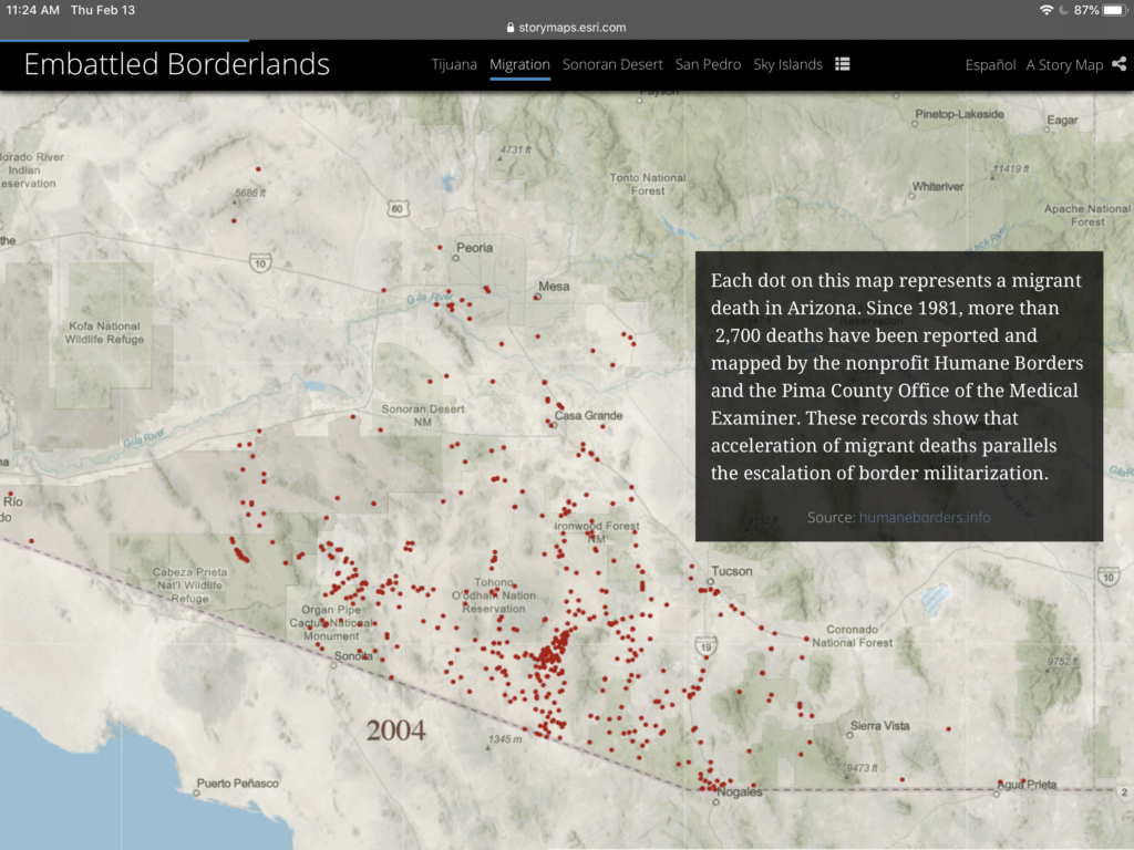
The “Migration” section incorporates exceptional uses of digital tools to illustrate human experiences. This section includes a digital map that computes the number of migrant deaths in Arizona since 1981. This map is followed by a real-world account of one of these deaths through interviews and photos. The creator has not specified a clear chronological scope. Within each section, one can see that Schyler includes political history throughout the 20th and 21st centuries. I think the decision to organize the information by location or topic rather than by decade strengthens each individual narrative. Forgoing a timeline presents each region as active, unique moving parts within a larger narrative. Furthermore, this casts the environment as a new lens from which to analyze history.
While I appreciate the utility of the drop-down menu, the introductory section and purpose of Embattled Borderlands is not included in this tool. Viewers could dive into the content without reviewing vital background context and not fully grasp the overall goal of this project. Furthermore, this project is missing a dedicated ‘about’ section. More information about Krista Schyler can be found at the very end of the story map, but this tidbit is informal and does not provide much scholastic background into the project. Nor can this be accessed directly through the drop-down tool.
Although the creator refrains from injecting a blatant political objective or interpretation throughout the Story Map, each section highlights the failures and injustices of American policies. Furthermore, Schyler encourages viewers to “take action” and offers ways to engage in the political conversation at the local and national level. While no political ideology is explicitly being pushed, including these resources may suggest to some that there is something wrong with the policies viewers have just encountered. However, I also think this is a way to empower individuals to also view themselves as significant pieces to the larger narrative.
Through Embattled Borderlands, Krista Schylerinvites viewers to examine border politics through the lenses of culture and the environment. Schyler and their collaborators have crafted an inclusive, informative, and personal illustration of local realities caught in between national politics. This effort is an example of effective cross-field collaboration facilitated through the means of Digital Humanities. This Story Map could be most useful for a wide range of professionals and academics within history, politics, environmental fields. At the same time, the language and content are familiar, therefore accessible enough to be grasped by local communities.